The amount of remote sensed imagery that has become available by far surpasses the possibility of manual analysis. One of the most important tasks in the analysis of remote sensed images is land use classification. This task can be recast as semantic classification of remote sensed images.
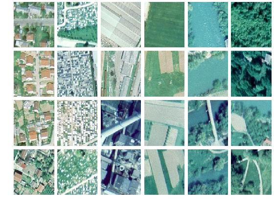
The database consists of 606 RGB aerial images of size 128*128 pixels. They have been obtained by partitioning a larger (4500*6000 pixels) ortophoto image of the part of Banja Luka, Bosnia and Herzegovina. In this image there is a variety of structures, both man-made, such as buildings, factories, and warehouses, as well as natural, such as fields, trees and rivers.
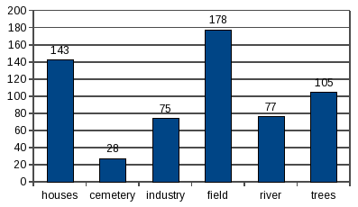
We manually classified all images into 6 categories. Examples of images from each category are shown in the figure, from left to right: houses, cemetery, industry, field, river, and trees.
The distribution of images in these categories is highly uneven
All images are in jpg format. The images provided here are for research purposes only.
In our experiments we used half of the images for training and the other half for testing.
Ratko Pilipović and Vladimir Risojević, "Evaluation of Convnets for Large-Scale Scene Classification From High-Resolution Remote Sensing Images", Proc. 17th IEEE International Conference on Smart Technologies IEEE EUROCON 2017, Ohrid, Macedonia, pp.955-960, July 2017. (pdf)(code)
Vladimir Risojević, "Analysis of Learned Features for Remote Sensing Image Classification", Proc. 13th Symposium on Neural Network Applications in Electrical Engineering NEUREL 2016, Belgrade, Serbia, pp. 151-156, November 2016.
(pdf)(code)
Vladimir Risojević, Zdenka Babić, "Unsupervised Quaternion Feature Learning for Remote Sensing Image Classification", IEEE Journal on Selected Topics in Applied Earth Observations and Remote Sensing, Volume 9, Issue 4, pp 1521-1531, April 2016, doi: 10.1109/JSTARS.2015.2513898
(pdf)(code)
Aleksej Avramović, Vladimir Risojević, "Block-based semantic classification of high-resolution multispectral aerial images", Signal, Image and Video Processing, Vol. 10, Issue 1, pp. 75-84, January 2016, doi: 10.1007/s11760-014-0704-x
(pdf)
Vedran Jovanović, Vladimir Risojević, "Aggregated Color Descriptors for Land Use Classification”, Telfor Journal, Vol. 7, Issue 2, pp. 91-96, December 2015.
(pdf)
Vedran Jovanović, Vladimir Risojević, “Evaluation of Bag-of-Colors Descriptor for Land Use Classification”, Proc. 22nd Telecommunications forum TELFOR 2014, Belgrade, Serbia, pp. 889-892, November 2014
(pdf)
Aleksej Avramović, Vladimir Risojević, “Analysis of spatial partitioning approaches for
image classification”, Proc. 12th Symposium on Neural Network Applications in Electrical Engineering NEUREL 2014, Belgrade, Serbia, pp. 211-216, November 2014
(pdf)
Vladimir Risojević, Zdenka Babić, "Unsupervised Learning of Quaternion Features for Image Classification", 11th International Conference on Telecommunications in Modern Satellite, Cable and Broadcasting Services TELSIKS 2013, Niš, Serbia, pp. 345-348, October 2013
(pdf)
Rok Češnovar, Vladimir Risojević, Zdenka Babić, Tomaž Dobravec, Patricio Bulić, "A GPU Implementation of a Structural-Similarity-Based Aerial-Image Classification", Journal of Supercomputing, Volume 65, Issue 2, pp 978-996, August 2013., doi: 10.1007/s11227-013-0875-1
(pdf)
Vladimir Risojević and Zdenka Babić, "Fusion of Global and Local Descriptors for Remote Sensing Image Classification", IEEE Geoscience and Remote Sensing Letters, Vol. 10, Issue 4, pp. 836-840, July 2013, doi: 10.1109/LGRS.2012.2225596
(pdf)(code)
Vladimir Risojević and Zdenka Babić, "Orientation Difference Descriptor for Aerial Image Classification", 19th International Conference on Systems, Signals and Image Processing, IWSSIP 2012, Vienna, Austria.
(pdf)
Vladimir Risojević and Zdenka Babić, "Aerial Image Classification Using Structural Texture Similarity", Proceedings of 11th IEEE International Symposium on Signal Processing and Information Technology, ISSPIT 2011.
(pdf)
A. Avramović, V. Risojević, "Descriptor Dimensionality Reduction for Aerial Image Classification", 18th International Conference on Systems, Signals and Image Processing, IWSSIP 2011.
(pdf)
V. Risojević, S. Momić, and Z. Babić. "Gabor Descriptors for Aerial Image Classification", In A. Dobnikar, U. Lotrič, and B. Šter, editors, Proceedings of 10th International Conference on Adaptive and Natural Computing Algorithms, ICANNGA 2011, Part II volume 6594 of Lecture Notes in Computer Science, pp.51-60, Springer Berlin / Heidelberg
(pdf)
This material is presented to ensure timely dissemination of scholarly and technical work. Copyright and all rights therein are retained by authors or by other copyright holders. All persons copying this information are expected to adhere to the terms and constraints invoked by each author's copyright. In most cases, these works may not be reposted without the explicit permission of the copyright holder.